Queen Catharine Creek Marsh Wildlife Management Area
Today I hiked a nearly 9 mile loop around the Queen Catharine Creek Marsh Wildlife Management Area in Watkings Glen, NY. Apparently, it's named after a local native american. The marsh is occassionally open to hunters and is managed by the NY State Department of Environmental Conservation. Supposedly it's an important bird migration site. Today I observed a few species of birds during my trip -- the only one I could identify is the popular Canadian goose.
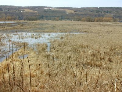
Typical view of the marshland from Cass Rd.
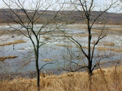
The Queen Catherine Creek Marsh Wildlife Management Area from Cass Rd.
I parked the Jeep on Cass Rd., which borders the marsh to the east. It's easily accessible from Route 79, just as you enter the village of Watkins Glen. No winter maintenance is provided, but that's usually not a problem for me. Anyway, today there was no snow or ice on the road -- just minor mud puddles. I parked several hundred yards away from Route 79 so that I could enjoy the entire walk. Had I driven further, I would have realized that I could have driven over small streams, formed after falling from several waterfalls which border the marsh to the east. Water empties into the marsh through these waterfalls from higher elevations. There must have been a lot recently, with the melting of several feet of snow.
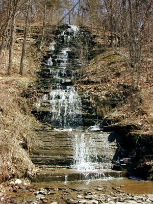
Several waterfalls run across Cass Rd. and empty into the marsh.
The picture below shows a waterfall against the sedimentary rock layers typical of the Finger Lakes Region and, it seems, especially Watkings Glen.

The ledges provide great views of the underlying geology of Watkins Glen.
The walk along Cass Rd. was pleasant enough, although it was unfortunate that about 3-4 miles of the path was along a road at all, even if only seldomly used. The color of the marshes, although interesting in its own way, pales in comparison to other hikes in the region, at least during this time of year. I suspect that hiking this region later in the spring would be much better. After about 4 miles on Cass Rd., the trail turned off the road and cut through a dry region of the marsh, along one of the canals. This was by far the most interesting part. I had never seen a marsh up close before and some of the imagery was what I expected, as shown below.
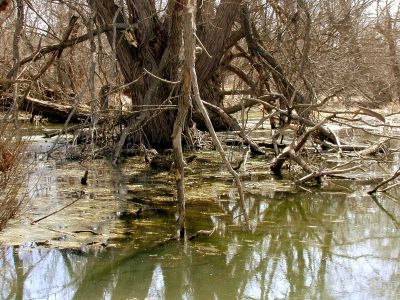
The southern part of the marsh looked more how I expected.
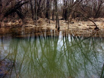
Differences of water color were quite interesting.

A look at the marsh from one of the foot bridges.
After awhile the trail passes by the site of an old airstrip. I saw no obvious remnants of the site. Although it's nice to know that the area has returned to its natural state, it would have been interesting to walk along the old runway. Near the supposed site was another canal whose crossing required the use of a rather unstable looking bridge structure. Fortunately, the bridge was far sturdier than it looked from afar.
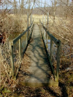
Would you cross this bridge?
At this point, at the south end of the marshes, about 5 miles into the round trip, the trail passes the Montour Falls Yacht Club. I was glad that the site was vacant. It was quite large and I'm sure that in the summer the area would have been crowded with boaters. The yachts actually travel along the west edge of the marshes and into Seneca Lake a few miles north. I had to cross a canal by walking along a bridge on Route 14 in Montour Falls at which point the trail headed back into the marshes. Eventually the trail ended up in Watkins Glen. There was supposed to be an abandoned railroad here, but I couldn't locate it. Instead I walked through Watkins Glen and ended up on the southern border of Seneca Lake. The lakeside in Watkins Glen can't compete with Cayuga Lake in Ithaca due to a super Wal-Mart and a gigantic salt refinery placed on its border. I met up with route 79 and walked another mile or so until I connected with Cass Rd., completing the loop. All things considered, I'm glad I investigated the marshes. The southern region was easily the most interesting and I may decide to see how the scenery changes in the summer.
Below is a satellite image of the area. In orange is an overlay of my track, generated with my GPS.

The Queen Catharine Marsh Loop in Watkins Glen, NY.

Typical view of the marshland from Cass Rd.


The Queen Catherine Creek Marsh Wildlife Management Area from Cass Rd.

I parked the Jeep on Cass Rd., which borders the marsh to the east. It's easily accessible from Route 79, just as you enter the village of Watkins Glen. No winter maintenance is provided, but that's usually not a problem for me. Anyway, today there was no snow or ice on the road -- just minor mud puddles. I parked several hundred yards away from Route 79 so that I could enjoy the entire walk. Had I driven further, I would have realized that I could have driven over small streams, formed after falling from several waterfalls which border the marsh to the east. Water empties into the marsh through these waterfalls from higher elevations. There must have been a lot recently, with the melting of several feet of snow.

Several waterfalls run across Cass Rd. and empty into the marsh.

The picture below shows a waterfall against the sedimentary rock layers typical of the Finger Lakes Region and, it seems, especially Watkings Glen.

The ledges provide great views of the underlying geology of Watkins Glen.

The walk along Cass Rd. was pleasant enough, although it was unfortunate that about 3-4 miles of the path was along a road at all, even if only seldomly used. The color of the marshes, although interesting in its own way, pales in comparison to other hikes in the region, at least during this time of year. I suspect that hiking this region later in the spring would be much better. After about 4 miles on Cass Rd., the trail turned off the road and cut through a dry region of the marsh, along one of the canals. This was by far the most interesting part. I had never seen a marsh up close before and some of the imagery was what I expected, as shown below.

The southern part of the marsh looked more how I expected.


Differences of water color were quite interesting.


A look at the marsh from one of the foot bridges.

After awhile the trail passes by the site of an old airstrip. I saw no obvious remnants of the site. Although it's nice to know that the area has returned to its natural state, it would have been interesting to walk along the old runway. Near the supposed site was another canal whose crossing required the use of a rather unstable looking bridge structure. Fortunately, the bridge was far sturdier than it looked from afar.

Would you cross this bridge?

At this point, at the south end of the marshes, about 5 miles into the round trip, the trail passes the Montour Falls Yacht Club. I was glad that the site was vacant. It was quite large and I'm sure that in the summer the area would have been crowded with boaters. The yachts actually travel along the west edge of the marshes and into Seneca Lake a few miles north. I had to cross a canal by walking along a bridge on Route 14 in Montour Falls at which point the trail headed back into the marshes. Eventually the trail ended up in Watkins Glen. There was supposed to be an abandoned railroad here, but I couldn't locate it. Instead I walked through Watkins Glen and ended up on the southern border of Seneca Lake. The lakeside in Watkins Glen can't compete with Cayuga Lake in Ithaca due to a super Wal-Mart and a gigantic salt refinery placed on its border. I met up with route 79 and walked another mile or so until I connected with Cass Rd., completing the loop. All things considered, I'm glad I investigated the marshes. The southern region was easily the most interesting and I may decide to see how the scenery changes in the summer.
Below is a satellite image of the area. In orange is an overlay of my track, generated with my GPS.

The Queen Catharine Marsh Loop in Watkins Glen, NY.


0 Comments:
Post a Comment
<< Home